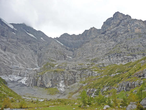
Chilchbalm Basin and cirque at the head of the Sefinental Valley
The Chilchbalm, a pretty glacial basin, lies beneath the rugged cirque at the head of the Sefinen Valley. The trail leading to the basin is perfect for anyone looking for a peaceful, relatively easy day hike accompanied by fine views of the Sefinen Lutschine (stream) and the rugged peaks rimming the Sefinen Valley.
- Distance: 5.8 miles (RT)
- Elevation: 4,470-ft. at Trailhead
Maximum elevation - 5,040-ft. - Elevation Gain: 570-ft.
- Difficulty: moderate
- Basecamp: Lauterbrunnen
- Region: The Bernese Oberland
Trail Description - Chilchbalm
This is a great trail for a cloudy/rainy day that precludes a trip to higher elevations. It is also a good option for anyone wanting a relaxing hike leading to an off-the-beaten path destination.
The trip can be extended by starting/ending the hike in Stechelberg or returning via Murren. Starting/ends in Stechelberg requires steep ascents/descents. The steep climb on the Murren option is rewarded with great view of the high peaks towering above the Lauterbrunnen Valley and beyond. Information on these options is found at the end of the hike description.
Gimmelwald to the Chilchbalm
The day starts by taking the bus from Lauterbrunnen to the Schilthornbahn and then riding the cable car to Gimmelwald (4,472-ft.), a small village of traditional wood buildings. (See trailhead directions below.) Outside the cable car station in Gimmelwald find the trail signpost and start walking southwest through the village on a paved road toward the Kilchbalm (an alternative spelling of Chilchbalm).
Ignore any trails descending toward Stechelberg. Instead continue heading toward the Kilchbalm. Soon the path curves to the southwest into the Sefinental (Sefinen Valley) where beautiful views open to the Ellstabhorn, Tschingelgrat (Tschingel Ridge), Gspaltenhorn and Butlasse rimming the valley.
At 0.4 miles reach a junction at a hairpin curve. Take the gravel trail, signed for the Kilchbalm, branching right off the paved path. A short distance beyond we leave the last of the houses behind as the broad path descends on moderate grades through meadows along the north side of the Sefinental valley. At 0.6 miles the path crosses a bridge over a stream and then continues descending through trees.
Reach the Sefinental junction on the floor of the Sefinen valley (4,134-ft.) at 1.2 miles. The trail to the left drops down to Stechelberg, an alternative starting location for the hike. (See below for more information.) We continue straight ahead on a path that ascends through pastures on moderate grades, passing a small alp along the way. The cirque, anchored by Butlasse and Gspaltenhorn, fills the skyline at the head of the valley.
Soon the pastures give way to trees and the valley constricts. Our trail now ascends on moderately steep grades beside a rushing stream, passing avalanche chutes and cliffs. At 1.8 miles the path crosses a bridge over a stream tumbling down the steep hillside above the trail.
Reach at junction at 2.0 miles. To the right is a trail heading toward Boganggenalp/Rotstockhutte and Sefinenfurgge, the pass between Lauterbrunnen and Griesalp. We bear left on the trail toward the Chilchbalm.
Beyond the junction the valley briefly widens as the trail travels through meadows with views of the cirque. After a quarter mile the path reenters the trees and crosses a stream on a wood bridge. The valley again constricts as we ascend steeply through trees and intermittent meadows to the Chilchbalm (5,040-ft.) at 2.6 miles.
The pretty glacial basin, clad in rocky meadows and sprinkled with stunted conifers, lies beneath the soaring cirque at the head of the Sefinen Valley. From the basin enjoy fine views of the rugged slopes of Butlasse and the Gspaltenhorn. Small waterfalls, fed by permanent snowfields and small glaciers, spill down the steep cliffs at the head of the valley. Behind you are great views of the Jungfrau rising above the Lauterbrunnen Valley.
As you wander up the basin the trail soon peters out and disappears at 2.9 miles. The upper end of the basin is a great place to take a break and enjoy the scene.
There are several options for the return journey from the basin. The easiest is to simply turn around and walk back to Gimmelwald for a 5.8 miles round trip hike. Alternatively, you could hike all the way back to Stechelberg for a 6.6 mile hike. Hikers looking for a longer, more challenging hike with great views should consider ascending the steep trail to Murren for an 8.9 mile hike.
Chilchbalm to Murren
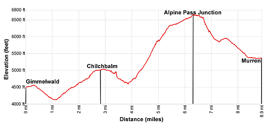
- Distance Gimmelwald to Chilchbalm to Murren: 8.9 miles
- Elevation at Murren: 5, 370-ft.
- Elevation Gain/Loss: 2,937-ft. / -2,046-ft.
- Difficulty: strenuous
To hike to Murren, retrace your steps to the junction with the trail to Sefinenfurgge at 3.8 miles and turn left toward the Sefinenfurgge. The path now climbs long switchbacks up very steep slopes along the north side of the Sefinen Valley, traveling through meadows and clusters of trees.
As you ascend, enjoy ever improving views of the peaks soaring above the Sefinen Valley. The Jungfrau and neighboring peaks tower above the Lauterbrunnen Valley to the east.
At 4.8 miles the grade abates a bit and views open to the Hundshorn and Schilthorn rimming a huge bowl to the west. Rugged cliffs and a photogenic horn rise to the southwest.
The path soon resumes its steep climb and reaches a junction at 5.0 miles. The trail straight ahead leads to the Rotstockhutte and the Sefinenfurgge. We turn right (east) toward Oberberg and Murren.
Past the junction the stiff climbs continues as the trail passes through Oberberg. Beyond the small hamlet the grade moderates as we continue ascending high above the north side of the Sefinen Valley. Ahead are great views of the Eiger, Monch, Jungfrau and nearby peaks rimming the east side of the Lauterbrunnen Valley.
Reach a junction with the Alpine Pass Route and the high point of the trail at 6.2 miles. To the left (west) the Alpine Pass route heads toward the Sefinenfurgge and Griesalp. We turn right toward Spielbodenalp and Murren.
At 6.3 miles ignore the trail to the left climbing to Bryndli and continue toward Murren. The trail now curves around the end of a ridge at the foot of the Sefinen Valley, emerging into the Lauterbrunnen Valley. Here views stretch northeast to the Wetterhorn and the Eiger. Across the valley the high peaks from the Jungfrau to the Breithorn dominate the view to the east/southeast.
At 6.5 mile the trail starts a steep decent down tight switchbacks. Take a break as you descend to enjoy the amazing views of the high peaks across the valley. The grade abates as the trail reaches Spielbodenalp and a junction at 7.0 miles. A restaurant at the alp enjoys fine views of the high peaks.
At the junction continue along the Alpine Pass Route toward Murren. The path descends through pastures, crosses a bridge over the Schiltbach (a small stream) and then ascends to a junction at a gravel road. Turn right on the road toward Murren.
The road descends on moderate to moderately-steep grades through pastures and travels by small alps. Along the way enjoy more fine views of the peaks to the east. At all intersections continue in the direction of Murren.
At 8.3 miles the grade abates as the trail reaches the outskirts of Murren and passes the cable car station with service to Stechelberg. Continue through the town, following the signs for the railway station. Reach the railway station at 8.9 miles. Here a train runs to the cable car that descends to Lauterbrunnen.
For an easier option, reverse the hike and walk from Murren to the Chilchbalm to Gimmelwald.
Starting the Hike at Stechelberg
- Distance Stechelberg to the Chilchbalm: 7.6 miles (round trip)
- Starting Elevation at Stechelberg: 2,893-ft.
- Elevation Gain: 2,147-ft.
- Difficulty: moderate
Hikers wishing to forgo the lift can start the hike at Stechelberg. This option requires taking the bus from Lauterbrunnen to the Stechelberg Hotel, the last stop on the line.
From the bus stop walk south through town and watch for a trail signpost marking the turn to the right toward the Chilchbalm. The trail travels through meadows and then begins a steep climb up the south side of the Sefinental valley. At 0.8 miles cross a bridge to the north side of the valley and continue the ascent on easier grades. The path soon reaches a junction with a broad track. Continue straight ahead on the track that ascends through trees along the north side of the creek, reaching the junction at Sefinental at 1.9 miles.
From the Sefinental junction follow the directions above to the Chilchbalm. The hike up from Stechelberg adds 0.8 miles to the hike (one-way) and 1,240-ft. in elevation gain.
Elevation Profile
Driving Directions
From Lauterbrunnen Bahnhof to Gimmelwald via the Schilthornbahn: From the bus stop near the northern end of the Lauterbrunnen Bahnhof (train station) take the #141 bus bound for Stechelberg and get off at the Schilthornbahn stop, the bottom station for the cable car system to the Schilthorn. The bus ride takes about 14 minutes. Note: There are many bus stops between the train station and the lift station. Check SBB website or download the SBB app for the current schedule and to find the stop near your accommodation.
At the Cable Car station, purchase a ticket for Gimmelwald. Take the cable car to Gimmelwald and exit the cable car station. Note: This is a four stage cable car that goes from bottom station to Gimmelwald and then to Murren, Birg and the Schilthorn, a popular viewpoint.
Lauterbrunnen Bahnhof to Stechelberg Hotel (last stop): Walk to the Lauterbrunnen Bahnhof bus stop, located at the north end of the station along the west side of the main road. Catch the #141 bus bound for Stechelberg (last stop). The ride should take about 20 minutes. There are a number of stops where you can catch the bus along the main road through Lauterbrunnen. Check the SBB website or download the SBB app for the current schedule and to find the stop near your accommodations.
From Stechelberg Hotel to the Lauterbrunnen Bahnhof (last stop): Walk north past the Stechelberg Hotel to the large parking lot and bus stop. Catch the #141 bus bound for the Lauterbrunnen Bahnhof. The ride should take about 20 minutes. The bus makes a number of stop along the main road through the village. Check the SBB website or download the SBB app for the current schedule and the stop near your destination.
From Murren to Lauterbrunnen: Walk to the Murren train station at the north end of the village. Take the train to the Murren Bergbahn, the cable car descending to Lauterbrunnen. The train ride takes 14 minutes and the cable car 4 minutes. The walk from the train to the cable car is short and you should have no problem making the connection.
Trail Resources
- Trail Photo Gallery
- Trail Maps
- Basecamp(s) Information: Lauterbrunnen
- Region Information: The Bernese Oberland
- Other Hiking Regions in: Switzerland