Lauterbrunnen to Stechelberg 
Distance: 4.3 miles
Bernese Oberland, near Lauterbrunnen in The Bernese Oberland
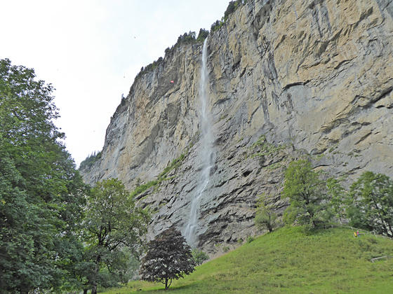
Staubbach Falls
This easy hike travels up the enchanting Lauterbrunnen Valley, a classic glacial valley rimmed with sheer cliffs and soaring glacier-clad peaks, passing many beautiful waterfalls on its way to Stechelberg near the head of the valley. Lovely meadows, small alps and the Weisse Lutschine River add to the scenic delights.
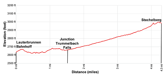
- Distance: 4.3 miles (One Way)
- Elevation: 2,610-ft. at Trailhead
Maximum elevation - 3,000-ft. - Elevation Gain: 390-ft.
- Difficulty: easy
- Basecamp: Lauterbrunnen
- Region: The Bernese Oberland
Trail Description - Lauterbrunnen to Stechelberg
Lauterbrunnen, which mean “many fountains,” is an apt description for the stunning valley said to have over 72 waterfalls. This easy hike follows a broad path up the valley floor, passing many impressive falls freefalling, tumbling and cascading down steep rock walls. Forming the backdrop for this captivating scene is the Breithorn and its neighboring peaks towering above the head of the valley.
This walk can be done in any weather. On a nice day the brilliant blue skies and emerald green meadows contrast beautifully with the peaks, adorn with glistening glaciers, at the head of the valley. My favorite time to do this hike is on a rainy day. Clouds will probably obscure the views of the high peaks but you will see an amazing number of waterfalls in all their glory, pouring from overhangs and splashing down rugged cliff faces.
Extend the hike by retracing your steps from Stechelberg back to Lauterbrunnen for an 8.6 miles round-trip hike.
Lauterbrunnen to Stechelberg
From the train station in Lauterbrunnen, walk south along the main street. At 0.3 miles, just before the street makes a sharp left turn, bear right on a side road. The turn is marked with yellow trail signs at the intersection pointing toward Trummelbach Hotel and Stechelberg. There is also a sign pointing toward the Jungfrau campground. As you walk down the road you'll pass the Horner Pub and then a large parking lot on your left. (This single lane road has little traffic and soon turns into a private road used only by the alps you pass along the way.)
You are now heading up the Lauterbrunnen valley, a classic “U” shaped glaciated valley with sheer rock walls. On your right the dramatic 975-ft. Staubbach Falls freefalls down a sheer cliff to the valley floor. At 0.5 miles a short spur trail climbing to the base of the falls is a worthwhile detour for anyone who would like an up-close shot of the waterfall.
Past the falls the road goes by a few houses and then a campground on your left. At all intersections continue heading south on the road. Beyond the campground the trail travels through pastures and small alps with views of more waterfalls tumbling down the walls on both sides of the valley. Straight ahead are fine views of the Breithorn and the Grosshorn towering above the head of the valley.
Reach Buchen at 1.5 miles. We continue straight ahead. The trail to the left leads to Trummelbach Falls. This 1.4 miles (round-trip) detour is an excellent diversion, leading to a World Heritage site where a series of waterfalls plummet down a slot canyon flowing within a mountain. See the description of the Trummelbach Falls Trail for more information.
The broad path soon nears the Weiss Lutschine River and then reaches a junction with the road leading across the river to the Breithorn campground and Sandbach at 2.1 miles. The next segment of the walk parallels the pretty river, passing a beautiful falls tumbling down the cliffs below the northern end of Murren, set atop a bench high above the valley floor.
At 2.6 miles reach a junction where the road turns to the left and crosses the river to Stegmatte. We continue along the west side of the river on a gravel path that soon enters the trees. In a short distance views open to a large car park across the river. The lot is for the Schilthornbahn, a multi-stage cable car that ascends to Gimmelwald, Murren, Brig and the Schilthorn. The Schilthorn is a popular viewpoint atop the summit of the Schilthorn with amazing 360-degree views and a revolving restaurant, Piz Gloria, that was featured in the James Bond movie, "On Her Majesty's Secret Service."
At 3.0 miles pass a small park with a picnic area on the right. The park offers views of a gorgeous waterfall cascading down the rugged cliffs beneath the southern end of Murren. Past the picnic area the trail breaks from the trees and soon passes a bridge over the river to the Schilthorn cable car station.
Keep to the west side of the river, admiring the falls seen from the picnic area along with a waterfall spilling down the valley’s sheer east wall. Ahead are fine views of the high peaks towering above the head of the valley.
At 3.6 miles pass a junction with a trail branching left toward Matte. Continue along the west side of the river toward the Stechelberg Hotel. More waterfalls are seen cascading down the east side of the valley. At 4.0 miles follow the trail as it turns left, crosses a stream and then travels between two buildings as it heads toward Stechelberg. At the next intersection, by the Alpehof Hotel, turn left toward Stechelberg. Upon reaching the main road turn left again. Walk past the Stechelberg Hotel to the bus stop on the left (west) side of the road 4.3 miles.
There are a number of restaurants in Stechelberg with scenic outdoor terraces where you can relax and get some refreshments before catching the bus to Lauterbrunnen. Alternatively, turn around and walk back to Lauterbrunnen for a 8.6 mile round-trip hike.
Elevation Profile
Driving Directions
Lauterbrunnen Bahnhof (train station) to the Stechelberg Hotel (last stop): Walk to the Lauterbrunnen Bahnhof bus stop, located at the north end of the station along the west side of the main road. Catch the #141 bus bound for the Stechelberg Hotel. The ride should take about 20 minutes. There are a number of stops along the main road through Lauterbrunnen to catch the bus. Check the SBB website or download the SBB app for the current schedule and nearest stop.
From the Stechelberg Hotel to the Lauterbrunnen Bahnhof (last stop): Walk north past the Stechelberg Hotel to the large parking area and bus stop. Catch the #141 bus bound for the Lauterbrunnen Bahnhof. The ride should take about 20 minutes. The bus makes a number of stop along the main road through the village. Check the SBB website or download the SBB app for the current schedule and the stop nearest to your destination.
Trail Resources
- Trail Photo Gallery
- Trail Maps
- Basecamp(s) Information: Lauterbrunnen
- Region Information: The Bernese Oberland
- Other Hiking Regions in: Switzerland