Backpack: Hailey Pass - Lizard Head - Cirque of the Towers Loop
Segment 3: Hailey Pass Trail to Valentine Lake
Distance: 9.8 miles (one way)
Bridger and Popo Agie Wildernessses, Bridger-Teton and Shoshone National Forest, near Big Sandy in Wyoming's Wind River Range
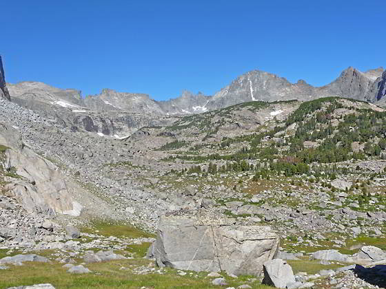
Cirque at the head of the Baptiste Valley
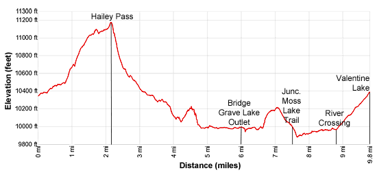
- Distance: 9.8 miles
- Elevation: 0.0 miles to Junction Hailey Pass Trail (10,375-ft.)
2.1 miles to Hailey Pass (11,160-ft.)
3.5 miles to Junction Baptiste Lake Trail (10,310-ft.)
4.7 miles to North shore of Grave Lake (9,964-ft.)
6.0 miles to Bridge over Grave Lake Outlet (9,975-ft.)
7.5 miles to Junction Moss Lake Trail (9,895-ft.)
8.7 miles to Junction Bear Ears Trail (9,980-ft.)
9.8 miles to Valentine Lake (10,399-ft.) - Difficulty: strenuous
- Basecamp: Big Sandy
- Region: Wyoming's Wind River Range
Hailey Pass Trail to Valentine Lake Description
Most parties spend a night a Mae’s Lake before crossing Hailey Pass. If you visit Mae’s Lake before crossing the pass, add 0.1 miles to the trail mileage in the description below.
From Mae’s Lake follow the Pyramid Trail south for a little over 0.1 miles and turn left (east/northeast) on the Hailey Pass Trail. (If heading north from Skull Lake, turn right (east/northeast) on the Hailey Pass trail.)
The trail soon turns northeast and crosses the outlet stream for a small lake located to the east of the trail. Beyond the creek the path travels on easy grades through spruce-pine forest high above the east side of Mae’s Lake.
At 0.8 miles the trail crosses the outlet stream for Twin Lakes and then climbs steeply toward the base of Pyramid Peak (12,030-ft.). As you climb the trees thin and fine views open to Mt. Geikie (12,378-ft.) to the west.
At 0.9 miles the trail curves to the right (east) and travels along the southern base of Pyramid Peak through meadows strewn with boulders. Soon the trail comes to a second crossing of the stream. Rock-hop across the stream and continue climbing on moderately-steep to steep grades. As you ascend the landscape becomes more rugged as the path weaves its way through meadows studded with rock outcroppings and large boulders.
Reach the third crossing of the creek at 1.3 miles. After rock-hopping across the creek the trail curves to the left (north) and climbs along the east facing slopes of Pyramid Peak. Large rocks dislodged from the slopes above the trail litter the hillside.
Lower Twin Lake (11,045-ft.) comes into view of 1.6 miles. The trail briefly traverses the lake’s western shore and then ascends a steep, rocky hillside above the lake to circumvent a large rock outcropping. At 1.7 miles the trail turn left (east) and descends to and crosses the creek linking upper and lower Twin Lakes. Past the crossing the trail curves to the left (north) and ascends gently to Upper Twin Lakes at 1.8 miles.
Follow the trail as it ascends on easy grades along the right (west) side of the upper basin, paralleling the lakeshore. Ahead, Mt. Hooker (12,504-ft.) is seen rising beyond Hailey Pass, the grassy saddle on the ridge at the head of the basin.
Beyond the lake a short stiff climb leads to Hailey Pass (11,160-ft.) and the boundary of the Popo Agie Wilderness at 2.1 miles. The views to the south are blocked by a ridge extending southwest from Dike Mountain (12,468-ft.). View to the north, while partially restricted by the ridges around the pass, are quite lovely. The Musembeah massif (12,593-ft.) along with Redwall Peak, Buttress Mountain and Grave Peak (12,255-ft.) rise above emerald green meadows of the Baptiste and Graves Creek Valleys. Mt Hooker’s distinctive profile towers above the pass to the northwest. Twin Lakes lie nestled in the alpine meadows below the pass to the south.
When you are done taking in the views head down the north side of Hailey Pass. The trail descends talus slopes on very steep switchbacks, losing over 500-ft. in a half mile. Mt. Hooker looms above the trail. To the north are great views of the Musembeah massif.
At 2.5 miles the grade abates briefly as the trail crosses a pretty meadow and then resumes its steep descent on grassy slopes strewn with large boulders. At 2.7 miles the trail travels along the east side of a creek for a short distance. Here views unfold to the north of the huge cirque surrounding the head of the Baptiste Valley, formed by the Musembeah massif, Cusp Peak (12,265-ft.), Mount Lander (12,623-ft.) and South Twin Lion (12,305-ft.). As you descend the views of the cirque continue to improve.
At 3.0 miles the grade abates a bit and first small trees appear. The descent continues on moderate to moderately-steep grades through meadows sprinkled willow thickets and small clusters of trees. Reach the crossing of Baptiste Creek, marked by a cairn atop a boulder, at 3.4 miles. During low water you may be able to rock-hop across the creek and keep your feet dry. Otherwise, wade across to the creek.
On the north side of Baptiste Creek is the junction with the trail to Baptiste Lake. (See the end of this description for more information on this side trip.) This junction is very easy to miss. Our trail, now officially the Bear Ears Trail, curves right (east) traveling along the north side of Baptiste Creek on easy grades.
At 3.7 miles the trail starts a moderately steep descent through trees down a rocky hillside. Openings in the forest offer views of a pretty waterfall on Baptiste Creek. The grade eases as 3.9 miles as the trail starts traversing high above Grave Lake (9,964-ft.).
The easy traverse is interrupted by Grave Lake Dome (aka Pilot Knob) (10,814-ft.), a dome with sheer cliffs rising 850-ft. above the lake’s northwest shore. At the base of the cliffs is a massive talus field. In order to circumvent the talus field and pass beneath the dome the trail climbs 150-ft., traverses a narrow bench above the talus field and then descends 225-ft. in 0.6 miles, reaching the lakeshore at 4.7 miles. Here the trail crosses a stream.
The path now heads east/northeast on easy grades through spruce-pine forest along the lake’s north shore. Openings in the trees offer views of the large, elongated lake that arcs around the north end of Chess Ridge, rising to the south. Valentine Mountain (11,147-ft.), Valentine Peak (11,361-ft.), Mount Chauvenet (12,250-ft.), Cathedral Peak and other unnamed summits fill the skyline to the southeast. Turn around for nice views of Mt Hooker and Graves Lake Dome to the west.
Nice campsites are found in the forested fringe around the lakeshore. The lake, which harbors good populations of lake and cutthroat trout, is popular with fishermen.
At 5.1 miles the path crosses Grave Creek and curves to the southeast through meadows, willow thickets and clusters or trees, paralleling the lakeshore. The open landscape offers nice view of the lake and the surrounding peaks.
At 5.5 miles pass the junction with the Onion Meadows trail branching to the left (east) near a small inlet with a nice sandy beach. Soon the trail travels a short distance along the lake’s outlet stream and crosses the stream on a good bridge 6.0 miles. On the south side of the bridge the trail continues its traverse along the lakeshore beneath a rock dome. Here terrific views to the northwest open to Mt. Lander, Pilot Knob and Musembeah Peak.
At 6.2 miles we leave the lake behind and travel southeast through spruce-pine forest on an undulating trail, reaching Lost Creek at 6.5 mile. Upstream a pretty waterfall cascades over a rock ledge. Rock-hop across the stream and start a short, steep climb over the ridge separating the Grave Creek and South Fork Little Wind River valleys. Along the way pass a small pond on the north side of the ridge.
Descend the ridge on moderate grades through trees to a creek crossing where our trail curves to the south. A short distance beyond, reach the junction with the Moss Lake Trail to Moss and Dutch Oven Lakes, branching to the left (east), at 7.5 miles. We continue heading south on the Bear Ears trails that ascends through trees on easy grades along the west side of the South Fork of the Little Wind River.
As you head upstream the trees give way to open meadows and willow thickets along the river bank. Soon views open to Buffalo Head (11,717-ft.) and the peaks forming the cirque at the head of the South Fork valley.
At 8.6 miles reach a "Y" intersection. Here the Washakie Trail heads right (southwest). We turn left (east) on the Bear Ears Trail, which drops down to a crossing on the South Fork of the Little Wind River. (Backpackers on the Hailey Pass/Washakie Loop should bear right on the Washakie Trail.)
Bear Ears Trail to Valentine Lake
The river ranges from shin to knee deep with a good current. Trekking poles or a stick are helpful to keep your balance when negotiating the slimy rocks along the river bed and during periods of high water.
On the east side of the creek the trail turns south and ascends through trees up a hot, dry hillside to Ranger Park at 8.9 miles. Here the trail turns left (east), crosses the north end of the park and reenters the trees. The trail now climbs switchbacks on moderate grades through trees to the outlet stream for Valentine Lake (10,399-ft.) at 9.8 miles.
Valentine Lake is set amid a backdrop of the sheer granite cliffs of the Lizard Head Plateau. Valentine Lake, or Little Valentine Lake further up the trail, are good places to spend the night before tackling the crossing of the Lizard Head Plateau.
Camping is not permitted around the Valentine Lake’s outlet stream. The best campsites are found along the lake’s western shore. To explore this area backtrack about 600-ft. from the outlet stream and look for a use trail heading left (south). (If you are coming up the trail from the South Fork the use trail is to your right.) The trail wanders between some large boulders and then fades as it crosses a meadow. Beyond the meadow you will find vestiges of trails that climb to campsites nestled atop the knolls and above small coves along the lake’s western shore.
Exploring around Valentine Lake
To the south of Valentine Lake are the seldom visited South Fork Lakes. To reach the lakes, find the use trail that travels along the low ridge to the west of Valentine Lake. This trail heads south into the area. Along the way you will pass Lake 10544 with very nice campsites. It is about 1.5 miles to the South Fork Lakes, nestled in a stunning basin surrounds by granite peaks and cliffs. The lakes are reported to have good fishing for cutthroat trout. Make sure you have a map to help you find the lakes and explore the area.
Side Trip to Baptiste Lake
To reach Baptiste Lake, follow the use trail that climbs steep through trees up the slopes above Baptiste Creek. Soon the grade abates and the route curves to the northwest, traveling through meadows with scattered trees. As you ascend we leave the last of the trees behind and pass between two ponds along Baptiste Creek, crossing the creek along the way. The trail fades as you ascend. Another climb leads to the southern shore of Baptiste Lake (10,845-ft.) at 1.5 miles.
From the south shore enjoy stunning views of the massive granite cirque surrounding the lake. The Musembeah massif rises to the east, Cusp Peak and Mount Lander tower above the valley to the north and Glissade Peak and Mount Hooker dominate the views to the west and south (respectively).
Beyond the south end of the lake is the Wind River Indian Reservation. A fishing license is required to proceed further into the basin.
Return to Segment 2: Marms Lake to Hailey Pass Trail Junction
Go To Segment 4: Valentine Lake to Cirque of the Towers Via Lizard Head
Elevation Profile
Backpack Segments
- Introduction: Hailey Pass - Lizard Head - Cirque of the Towers Loop
- Segment 1: Big Sandy Trailhead to Marms Lake
- Segment 2: Marms Lake to Hailey Pass Trail Junction
- Segment 3: Over Hailey Pass to Valentine Lake
- Segment 4: Valentine Lake to Cirque of the Towers Via Lizard Head
- Segment 5: Cirque of the Towers to Big Sandy Trailhead via Jackass Pass
Driving Directions to Big Sandy Trailhead
The Big Sandy Trailhead is located in the southern Wind River Range next to the Big Sandy River.
Directions from Pinedale: From the intersection of Pine Street (US 191) and North Tyler Ave (the Pinedale Tourism office is located on the northeast corner) in Pinedale, WY, drive south on Highway 191 for 11.7 miles and then turn left (east) on WY-353. After 15.5 miles you will notice signs referring to the road as the Big Sandy-Elkhorn Road and after 18 miles the paved road will change to a good packed dirt/gravel surface.
Shortly after the pavement ends go straight through a junction, and drive south crossing the Big Sandy River (Buckskin Crossing). Follow the road for a total of 27.3 miles. Shortly after crossing the Big Sandy River you will reach a junction with the Lander Cutoff Road (the next junction). Turn left on the Lander Cutoff Road. There is a wood sign at the intersection pointing toward the Big Sandy trailhead.
Drive 7.0 miles on the Lander Cutoff Road and then turn left on the Big Sandy Opening Road. Here you will see a sign for the Big Sandy Campground and trailhead. The road now deteriorates and narrows. Blind corners and lush foliage along the road make it hard to see ahead. Drive carefully, following the rocky, rutted road for 9.8 miles to a "Y" intersection. Bear right at the intersection to continue along the Big Sandy Opening Road (Forest Service Road 850). (The road branching to the left leads to the Big Sandy Lodge and Mud Lake.) Follow the road for 0.8 miles to the trailhead parking area, equipped with an outhouse.
Allow an hour and a half to reach the trailhead from Pinedale. The parking area is too small for the number of backpackers visiting the area during the height of the summer. If the parking area is full, find a safe place to park off the access road.
I recommend a high clearance vehicle to reach the trailhead. Passenger cars can make it OK if driven carefully. Check at the Pinedale ranger station before starting your trip to learn about current road and trail conditions. The Ranger Station is located to the east of the Ridleys Grocery Store on US 191 (Pine Street in Pinedale). The entrance to the ranger station is on the Fremont Lake Road. (You can also reach the parking area for the ranger station by driving east through the Ridley’s parking lot.)
This trailhead is remote, so be sure to have a full tank of gas. The dirt road become slippery when wet. The campground at the parking area is tiny, with only 4 sites. I would not plan on camping at the trailhead before starting your backpack.
Trail Resources
- Backpack Intro
- Segment Photo Gallery
- Segment Map
- Trailhead(s) Information: Big Sandy
- Region Information: Wyoming's Wind River Range
- Other Hiking Regions in: Wyoming