Mono Pass 
Distance: 7.0 - 8.5 miles (round trip)
John Muir Wilderness Area, Inyo National Forest, near Mammoth Lakes in California's Southeastern Sierra
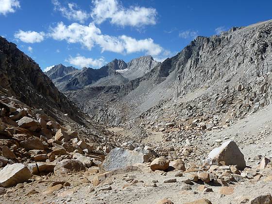
Looking south from Mono Pass (12,064-ft.)
This stiff climb to Mono Pass features fine views of the Little Lakes Basin, Ruby Lake, the Mono Recesses and Pioneer Basin.
See Trail Detail/Full Description
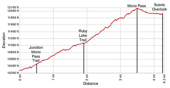
- Distance: 7.0 miles (round trip) to Mono Pass
8.5 miles (round trip) to Scenic Overlook - Elevation: 10,200-ft. at Trailhead
12,060-ft. at Mono Pass
11,890-ft. at Scenic Overlook - Elevation Gain: 1,860-ft. to Mono Pass
2,030-ft. to Scenic Overlook - Difficulty: strenuous
- More Hikes in:
Mammoth Lakes / Bishop / California's Southeastern Sierra
Why Hike Mono Pass
Stunning views of the Little Lakes Basin, the sheer granite walls towering above Ruby Lake and stark landscape beneath the towering summit of Mt. Starr (12,835-ft.) are a few of the scenic rewards of this strenuous hike to Mono Pass (12,060-ft.). Starting at 10,200-ft. the trail climbs a series of steep switchbacks, gaining 1,860-ft in 3.5 miles. An optional extension beyond the pass leads to Summit Lake and an overlook with views of the peaks rising above the Mono Recesses and Pioneer Basin to the northwest.
While not as crowded as the nearby trail traveling up the Little Lakes Valley the Mono Pass trail receives a good amount of traffic so do not expect solitude. In addition to day hikers, a steady stream of backpackers cross the pass each day on their way to the Mono Creek drainage, where trails lead to scenic Pioneer Basin and a series of beautiful side canyons, the Mono Recesses, further down the valley.
Elevation Profile
Trail Resources
Trail Detail/Full Description / Trail Photo Gallery / Trail Map
Basecamp(s) Information:
Mammoth Lakes / Bishop
Region Information:
California's Southeastern Sierra
Other Hiking Regions in:
California