White Chief Canyon 
Distance: 7.4 - 9.2 miles
Sequoia-Kings Canyon National Park, near Mineral King in California's Southwestern Sierra
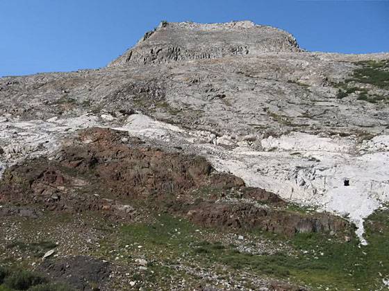
The White Chief Mine (look in the white rocks on the right side of the photo)
Multi-hued rugged canyon walls, pretty meadows sprinkled with wildflowers and a dramatic glacial cirque are the scenic delights of this great hike up White Chief Canyon.
- Distance: 7.4 miles (round trip) to White Chief Mine
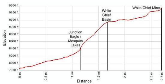
9.2 miles (round trip) to White Chief Bowl - Elevation: 7,830-ft. at Trailhead
9,636-ft. at White Chief Mine
10,050-ft. at White Chief Bowl - Elevation Gain: 1,806-ft. to White Chief Mine
2,220-ft. to White Chief Bowl - Difficulty: moderate-strenuous
- Basecamp: Mineral King
- Region: California's Southwestern Sierra
Trail Description - White Chief Canyon
The White Chief trail starts at the south end of the Eagle / Mosquito parking area. Follow the trail as it heads south, ascending along the west side of the beautiful East Fork Kaweah River valley on an easy grade through scrub covered hillsides, sprinkled with scattered fir and junipers. A profusion of willows grow along the river banks and in the marshy areas of the meadows lining the valley floor. Vandever Mountain (11,947-ft.) and Farewell Gap, the saddle to the east of the peak, frame the head of the valley.
Cross a small wood bridge over Spring Creek at 0.3 miles. Tufa Falls, a small waterfall on the creek, is hidden by the thick foliage above the trail. Water flowing in the creek is believed to travel underground along fractured marble bands that surface on the hillside high above the trail.
Beyond the creek the trail continues it steady ascent, passing through scatter stands of firs and junipers. Across the valley Crystal Creek tumbles down a rocky cleft carved in the steep hillside.
Eagle Creek cascades over the trail at 0.9 miles and is easily crossed on rocks. Past the creek the trail steepens and reaches a junction at 1.2 miles. The trail to the right leads to Eagle and Mosquito lakes. Follow the trail heading left, signed for White Chief Canyon, as it continues its very steep ascent up the west side of the valley through pockets of firs, junipers and mixed pines. Take occasional breaks from the stiff climb to enjoy views of the peaks towering above the east side of the valley.
At 1.7 miles the trail reaches the pretty White Chief basin and the grade abates. Follow the trail as it wanders up the narrow valley, carpeted with pretty meadows and rimmed by rugged colorful cliffs in shades of white, orange, red, brown and gray. At the lower end of the meadow be sure to look for the remains of the Crabtree Cabin, located on the right (west) of the trail just before a crossing of White Chief Creek. The structure, thought to be the oldest remaining building in the Mineral King area, was built by James Crabtree, the miner who discovered the White Chief mine.
At the south end of the meadows follow the trail as it continues its ascent along the east side of the canyon to a spot below the White Chief mine. (Look for white tailings spilling from the marble strata on the rock face above the west side of the trail.) The trail now crosses the creek and climbs to the mine, located 3.7 miles from the trailhead.
Beyond the mine a faint trail, marked with cairns, traverses along the west side of the canyon to the upper basin. The photogenic upper basin, which contains numerous mine shafts, sinkholes and caverns along with the ruins of mining cabins, ends at a White Chief Bowl (10,050-ft.), tucked in a huge glacial cirque beneath the west face of Vandever Mountain (11,947-ft.) located 4.6 miles from the trailhead. Total elevation gain from the trailhead to the bowl is 2,220-ft.
Cross-country routes along the White Chief Canyon trail lead to White Chief Lake, Ansel Lake and White Chief Peak (11,159-ft.).
Elevation Profile
Driving Directions
From Visalia: Follow Highway 198 East for 31.5 miles to the Mineral King Road. (There is a small green sign by the road that read “Mineral King 25 miles”.) Turn right onto the Mineral King Road and follow the narrow, winding road for 23.5 miles to the Eagle/Mosquito parking lot at the end of the road.
Trail Resources
- Trail Photo Gallery
- Trail Maps
- Basecamp(s) Information: Mineral King
- Region Information: California's Southwestern Sierra
- Other Hiking Regions in: California