Details: North Pole Basin 
Distance: 7.0 miles (round trip)
Maroon Bells-Snowmass Wilderness, White River National Forest, near Crested Butte in Central Colorado
Hike Facts
- Distance: 7.0 miles (round trip)
- Elevation: 10,360-ft. - 12,190-ft.
- Elevation Gain: 1,830-ft.
- Difficulty: moderate-strenuous
- Trail Highlights: See Trail Intro
- Basecamp(s): Crested Butte
- Region: Central Colorado
Few hikers know about the gorgeous North Pole Basin. Scenic highlights include pristine meadows, cascading waterfalls, wildflowers and rugged peaks. A short off-trail stint leads to a saddle with breathtaking views of the high peaks of the Elk Mountains.
Trailhead to North Pole Basin
Please note: This hike passes through land owned by the Rocky Mountain Biological Laboratory (RMBL) and the Crested Butte Land Trust (CBLT). No dogs or bicycles are allowed and no fishing or hunting is permitted on the property.
From the intersection of the Gothic/Schofield Pass Road and the unmarked North Pole Basin road (see driving directions), bear left (northwest) on the North Pole Basin road. Soon the road turns left (west) and crosses the South Fork of the Crystal River. Beyond the crossing the two-track dirt/gravel road turns right (northwest) ascending on moderate grades through spruce/fir forest. Openings in the trees offer occasional views of the 12,000-ft peaks rising along the east side of the South Fork Crystal River valley.
Reach a metal gate at 0.7 miles blocking vehicles from continuing up the road. A short distance beyond pass a red sign posted on a tree indicating that you are now on land owned by the RMBL and the CBLT. The site, once a private resort, was purchased in June of 2013 and is now open to public access. Prior to the resort the valley was home to the North Pole mine, which produced silver and copper ore.
The road now curves to the left (southwest) as it ascends on easy grades, passing an old cabin on the right side of the road. As you climb through the basin you will pass more remnants of the resort and a few mining relics.
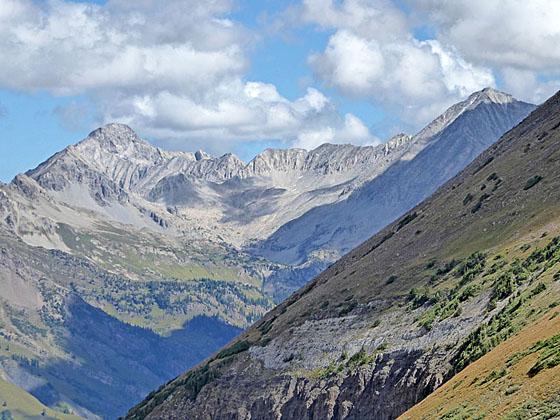
At 1.1 miles the trail turns to the right (west) and travels through small meadows beneath the north facing slopes of Galena Mountain (12,580-ft.). Here views open to the Snowmass Peak and the summits rising above Geneva Basin to the north. Looking up the valley the distinctive diagonal stripes of white and gray rock along Crystal Mountain’s southwestern ridge provide an excellent example of geologic uplift and tilting.
Soon you will reach a flooded section of the road where the track turns right (northwest) and skirts the east side of a pond. Follow a use trail that continues straight ahead for a short distance to a dam. Turn right and cross the dam. A section of the dam is now broken, submerging the road. When I was last in the basin a piece of wood spanned the gap to facilitate the crossing. If the wood is missing you should have no problem jumping the gap. On the north side of the dam the use trail briefly travels between the pond and a cluster of willows before rejoining the road.
Past the dam follow the road as it ascends through trees and meadows along the north side of the valley, avoiding the boggy meadows and ponds on the valley floor. You may see areas of the valley which are cordoned off for scientific work. Please respect these closures and stay on the road as you pass through the RMBL/CBLT property.
At 1.5 miles views open to a waterfall cascading down a rocky slope. Soon the road turns to the left (south) and travels along a low ridge, passing ponds surrounded by dense willows on the valley floor before turning back to the right (west).
Reach the foot of the largest pond in the basin at 1.8 miles. Treasure Mountain (13,462-ft.) towers above the basin to the west. Crystal Mountain (12,632-ft.) rises to the northwest. During the early morning Crystal Mountain’s uplift bands are nicely mirrored in the pond’s still waters.
The trail now climbs on moderate grades through meadows and small cluster of trees along the north side of the valley. As you ascend enjoy ever improving views of beautiful North Pole basin. Waterfalls cascades through pristine meadows scattered with willows and stunted conifers. Treasure Mountain dominates the views at the head of the basin while Galena Mountain rises to the south.
Reach a sign marking the western boundary of the RMBL/CBLT property at 1.9 miles. Past this point you are on National Forest lands. A tenth of a mile beyond the sign the road splits. Take the path to the right that climbs steeply along the southeast facing slopes of Crystal Mountain. As you gain altitude turn around to see Bellview Mountain (13,233-ft.) rising above the East Fork Valley and the summits of Maroon Bells to the east.
The trail begins curving left (south) at 2.25 miles. Soon the grade abates as the trail continues its ascent on easy to moderate grades high above the west side of the basin. Galena Mountain looms above the valley to the east. An old mining road cuts across the peak’s talus slopes.
At 2.9 miles the trail curves to the right (southwest/west) as it enters the hanging valley beneath the north face of Treasure Mountain. A small pond lies cradled in a tundra-clad bowl in the center of the basin. Our trail climbs along north side of the basin and soon curves to the right (northwest). The road fades in places but is not difficult to follow.
Reach a junction of sorts at 3.2 miles. Ahead an old two-track road curves to the left (west). A faint trail, branching to the right (northwest) climbs the meadows to the road above. My advice is to bear right and climb to the road with the objective of reaching the saddle on the ridge between Crystal and Treasure Mountains.
Once you reach the upper road look north toward the saddle. Plot a cross-country route that climbs the meadows to the saddle, avoiding the talus. The steep climb, gaining about 200-ft. in 0.2 miles, is accompanied by great views of the upper basin and the peaks rising to the east.
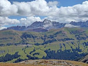
From the saddle (12,190-ft.) enjoy stunning views of the Maroon Bells to the east. The pretty meadows of Bear Basin lie beneath the saddle to the west. Capitol Peak (14,130-ft.), Snowmass Mountain (14,092-ft.) and the peaks surrounding the Geneva Lake basin dominate the view to the north while a sea of summits in the Elk Range fills the skyline to the northwest. Closer at hand is Crystal Peak rising along the ridge to the northeast of the saddle.
When you are done taking in the amazing views drop down from the saddle to the road and retrace your steps to the trailhead. On the return trip the peaks of the Maroon Bells are now directly in front of you during the descent.
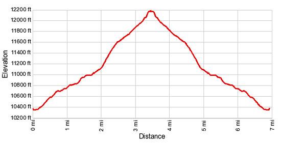
Elevation Profile
Buy the BookThis opinionated guide includes all the hikes in the Aspen, Buena Vista, Crested Butte, Marble and Leadville sections of the website plus info on local services and nearby attractions. | |
Driving Directions
Driving Directions from Crested Butte: From the intersection of Elk Avenue (main street) and 6th Street in Crested Butte, head north on 6th Street, which turns into Gothic Road (sometimes referred to as the Schofield Pass Road). Follow the Gothic Road (CO 317) for 13.2 miles to Schofield Pass, passing the ski area and the research facilities at Gothic along the way. The dirt road is suitable for 2WD cars up to the town of Gothic at 7.9 miles. Beyond Gothic the road become rougher and a high clearance/4WD vehicle is required.
Continue on the road over Schofield Pass, descending the north side of the pass on switchbacks and then through meadows for 1.2 miles. Pass the East Fork trailhead on the right (east). Immediately after a sign announcing the “End of County Maintenance” is a road branching to the left (northwest). This is the road to the North Pole basin. Find a place to park off the Gothic/Schofield Pass road in the area near the intersection. You can also park at the East Fork trailhead, 0.4 miles back up the road.
It is possible to drive up the North Pole road for 0.7 miles to a pull off on the right (east) side of the road where there is room for a few cars. Beyond the pull off is the gate marking the beginning of the North Pole Basin parcel owned by Rocky Mountain Biological Laboratory and the Crested Butte Land Trust. The land between the pull off and the Gothic / Schofield Pass Road is private property. Don’t park along this section of the road. I recommend parking at a safe spot off the Gothic /Schofield Pass road and walking up the North Pole Road, a very pleasant walk through a forest with intermittent views of the peaks to the east.
Trail Resources
Trail Intro / Trail Photo Gallery / Trail Map
Basecamp(s) Information:
Crested Butte
Region Information:
Central Colorado
Other Hiking Regions in:
Colorado