Porphyry Basin 
Distance: 5.0 - 7.0 miles (round trip)
Uncompahgre National Forest, near Silverton in Southwest Colorado
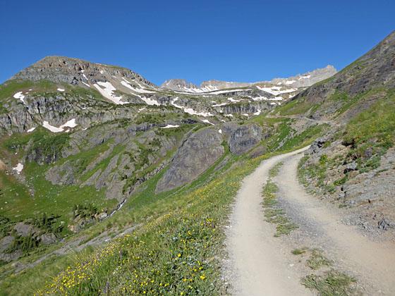
First view of Porphyry Basin
This scenic hike climbs to two pretty lakes in gorgeous Porphyry Basin. Along the way the trail travels through wildflower-filled meadows and passes waterfalls, interesting rock formations and mining ruins. The lovely alpine meadows of the upper basin offer several options for off-trail exploration.
See Trail Detail/Full Description
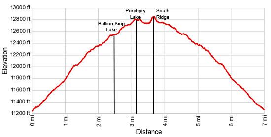
- Distance: 5.0 miles (round trip) to Bullion King Lake
6.4 miles (round trip) to Porphyry Lake
7.0 miles (round trip) to South Ridge Overlook - Elevation: 11,230-ft. at Trailhead
12,570-ft. at Bullion King Lake
12,800-ft. at Porphyry Lake
12,890-ft. at South Ridge Overlook - Elevation Gain: 1,340-ft. to Bullion King Lake
1,570-ft. to Porphyry Lake
1,660-ft. to South Ridge Overlook - Difficulty: moderate
- More Hikes in:
Silverton / Ouray / Southwest Colorado
Why Hike Porphyry Basin
Typically I am not a big fan of walking jeep roads, but I make an exception when it comes to Porphyry Basin. This scenic, off-the-beaten path hike ascends to Bullion King Lake nestled in the stunningly beautiful Porphyry Basin. The initial segment follows a lightly trafficked dirt road and then a trail. Beautiful, wildflower-filled meadows, pretty waterfalls, interesting rock formations and remnant of old mines accompany the walk.
Beyond the lake faint trails and some route finding leads to the upper basin where lovely Porphyry Lake lies cradled beneath Three Needles Peak (13,481-ft.). The upper basin's open alpine meadows invite exploration. Off-trail routes climbing to saddles on the ridges to the north and west of Porphyry Lake offer terrific views into Bridal Veil Basin. Hikers ascending the route to the ridge crest rimming the south side of the basin are rewarded with a panorama of peaks extending from the Needles in the Grenadier Range in the southeast to the high peaks of the Uncompahgre Wilderness to the northeast.
Elevation Profile
| Buy the BookThis opinionated guide includes all the hikes in the Ouray, Telluride, Silverton and Lake City sections of the website plus info on local services and nearby attractions. |
Trail Resources
Trail Detail/Full Description / Trail Photo Gallery / Trail Map
Basecamp(s) Information:
Silverton / Ouray
Region Information:
Southwest Colorado
Other Hiking Regions in:
Colorado