Allmenalp to the Bunderspitz 
Distance: 4.4 miles
Bernese Oberland, near Kandersteg in The Bernese Oberland
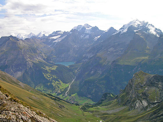
High peaks towering above Oeschinensee
Hikers completing the very steep climb to the summit of the Bunderspitz are rewarded with amazing views of the cirque soaring above the Oeschinensee along with the high peaks towering above the head of the Kandertal and Adelboden (Engstligental) Valleys.
- Distance: 4.4 miles (RT)
- Elevation: 5,653-ft. at Trailhead
Maximum elevation - 8,353-ft. - Elevation Gain: 2,700-ft.
- Difficulty: killer
- Basecamp: Kandersteg
- Region: The Bernese Oberland
Trail Description - Allmenalp to the Bunderspitz
To say that this hike is steep is an understatement but the panoramic views atop the Bunderspitz are worth the effort. From this airy overlook the Grindelwald triumvirate –the Eiger, Monch and Jungfrau grace the horizon beyond the breathtaking cirque ringing the Oeschinensee. Prominent peaks include the Dundehorn, Bluemlisalphorn, Frundenhorn and Doldenhorn. Further up the Kandertal (Kander Valley) Altels, the Balmhorn and the Rinderhorn punctuate the skyline.
To the west/southwest the peaks and ridges rimming the Adelboden Valley dominate the view while First and the Elsighorn rise along the Allmegrat ridge to the north. To the south the Wildstrubel, Glacier de la Plaine Morte and nearby peaks grace the horizon.
To the Bunderspitz
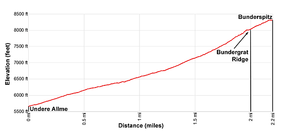
The day starts with a ride on the Allmenalp Cable Car, which climbs over 1,800-ft. above the valley floor in only 5-minutes, to Allmenalp (5,653-ft.), aka Undere Allme on some maps. (See trailhead directions below.) Outside the station head west on the steep, broad track toward Obere Allme and the Bunderspitz.
The path ascends along the north side of the valley, aided by a few switchbacks. Behind you, across the valley, are grand views of the Doldenhorn, Bluemlisalphorn, Wyssi Frau and Dundehorn, anchoring the cirque soaring above the Oeschinensee.
At 0.6 miles, just before Obere Allme, reach a junction with a trail branching right toward First. (See the First hike for more information.) We turn left, staying on the broad track toward Obere Allme and the Bunderspitz.
At 0.8 miles pass Obere Allme, located along a hairpin curve. A short distance beyond you will see a trail branching left. Take this trail, which short-cuts a switchback along the track. The trail quickly rejoins the track and then passes a farm building on the right. A short distance past the building the track gives way to a trail ascending steeply through meadows.
Reach a junction at 1.4 miles. Here the trail to Bunderchrinde branches left. We continue straight ahead toward the Bundergrat ridge and the Bunderspitz.
Soon the grade becomes noticeable steeper as the path climbs through rocky meadows and scree covered slopes on tight switchback. Behind you the views continue to improve and evolve. As you gain elevation the Eiger, Monch and Jungfrau appear beyond the Oeschinensee cirque. Ahead are fine views of Chlyne Loner, the Bundergrat ridge and the Bunderspitz.
The trail, while very steep, is not exposed. As you approach the ridge crest a wire cable, attached to a cliff face, facilitates the climb and adds a level of safety.
Reach the top of the Bundergrat ridge (8,058-ft.) and a junction at 2.0 miles. Here we turn right toward the Bunderspitz. (The trail to the left leads to the Bunderchrinde and Adelboden.) A stiff climb up the west facing slopes just below the ridge crest leads to the summit of the Bunderspitz (8,353-ft.) at 2.2 miles.
The summit enjoys superb views. Without a doubt the stars of the show are the high peaks ringing the Oeschinensee and the summits of the big-three; the Eiger, Monch and Jungfrau, rising beyond Hohturli Pass. Altels, Balmhorn and the Rinderhorn, towering above the east side of the Kandertal valley, appear through a break in the ridge to the south.
The Wildstrubel and the Glacier de la Plaine Morte dominate the views to the south while the Gsur and Albristhorn punctuate the ridge rising above the west side of Adelboden. First, another fine overlook, is seen along the knife edge ridge to the north.
When you are done taking in the views, retrace your steps the trailhead for a 4.4 mile hike.
Elevation Profile
Driving Directions
From Kandersteg to the Valley Station for the Allmenalp Cable Car: From the Kandersteg Bahnhof (train station), walk south along the paved pedestrian walkway paralleling the east side of the tracks. Turn right (west) when you reach Butschelstrasse, the street going under the tracks. Beyond the railway line the road curves to the left (southwest) and soon becomes Allmenbahnstrasse. Signs along the way point to the Allmenalpbahn (cable car). The walk should take about 15 minutes. See the Allmenalp Luftseilbahn for information on the schedule and prices.
Trail Resources
- Trail Photo Gallery
- Trail Maps
- Basecamp(s) Information: Kandersteg
- Region Information: The Bernese Oberland
- Other Hiking Regions in: Switzerland