Davos Alpentour – Glaris to Schatzalp 
Distance: 10.8 miles (one way)
near Davos in Eastern Switzerland
Amselflue
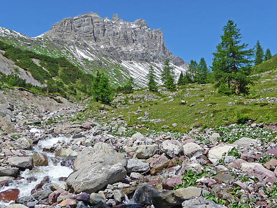
This lovely walk traverses above or near the timberline along the west side of the Davos Valley with fine views of the peaks towering above the east side of the valley and the summits rimming the ridge to the west. Alternative destinations allow hikers to easily shorten the walk.
See Trail Detail/Full Description
- Distance: 10.8 miles (one way) to Schatzalp
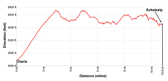
- Elevation: 4,734-ft. at Trailhead
6,670-ft. at Schatzalp - Elevation Gain: 1,926-ft. to Schatzalp
- Difficulty: moderate-strenuous
- More Hikes in:
Davos / Eastern Switzerland
Why Hike Davos Alpentour – Glaris to Schatzalp
This mid-level walk, traversing above or near the timberline along the west side of the Landwasser Valley (the valley where Davos is located), features great views of the high peaks towering above the east side of the valley as well as the summits rising above the trail to the west.
After climbing above Glaris the undulating trail heads north staying between 6,100-ft to 6,700-ft. on its way to Schatzalp, where a funicular whisks hikers down to Davos Platz. The path can be walked in either direction. Walking north, as described below, requires a moderate to moderately-steep ascend from the valley floor to the traverse. Walking south is rated as moderate since it utilizes the funicular to reach the traverse and then drops down to Glaris at the end of the hike. I like both directions.
Shorten the hike by using one of the many trails that drop down to bus stops and train stations along the valley floor. The hike can also be shortened by starting the hike at Frauenkirch and climbing to Stafelalp (1,270-ft. elevation gain).
The Alpentour is a great option if there is snow at higher elevations or the weather precludes hiking in the high country. Hikers looking for an easier day will also appreciate this scenic path that passes through pretty meadows and visits small villages.
Be forewarned that you will be sharing the trail with mountain bikes. I have not found this generally to be a problem.
Due to the undulating nature of this trail, the elevation gain and loss is greater than the net difference between the high and low points on the hike.
Elevation Profile
| Support our Site |
Trail Resources
Trail Detail/Full Description / Trail Photo Gallery / Trail Map
Basecamp(s) Information:
Davos
Region Information:
Eastern Switzerland
Other Hiking Regions in:
Switzerland