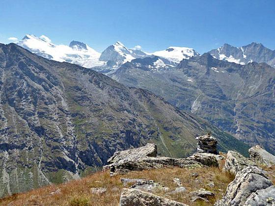
View of the Strahlhorn, Rimpfischhorn, Allalinhorn, Alphubel, Taschhorn and Dom
This trail starts at the scenic overlook at Heidbodme, with panoramic views of the peaks towering above the Saastal. The path then travels on a high route along the eastern slopes of the Furgg Valley to Antrona Pass, a remote and wild saddle on the Swiss-Italian border.
See Trail Detail/Full Description
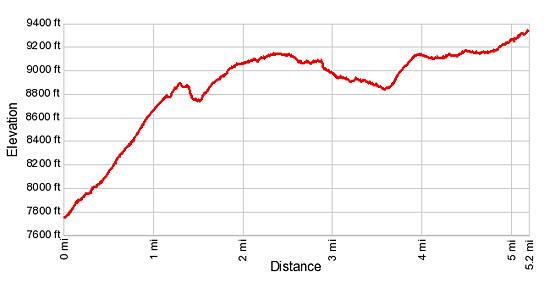
- Distance: 10.4 miles (round trip)
- Elevation: 7,685-ft. at Trailhead
Maximum elevation: 9,311-ft. - Elevation Gain: 2,126-ft.
- Difficulty: strenuous
- More Hikes in:
Saas Fee / The Valais
Why Hike Antrona Pass via Heidbodme
Antrona Pass, on the Swiss-Italian border, was once an important medieval trade route that fell into disuse after a massive landslide in 1642 almost wiped out the village of Antronapianna on the Italian side. Today the pass offers a pleasant refuge from the crowded viewpoints around the Saas Valley. Here there are no ski lifts, huts or cafes. Instead the pass retains a remote, wild feeling with extended views of the Furgg Valley in Switzerland and the high peaks along the south side of the Troncone Valley in Italy.
Two trails lead to Antrona Pass. This hike starts at Heidbodme, a scenic overlook with panoramic views of the peaks rising along the west side of the Saastal, including the Strahlhorn and Rimpfischhorn towering to the west of the Mattmark area and the peaks forming the cirque around Saas Fee, the Allalinhorn, Alphubel, Taschhorn, Dom and Lenzspitze. Directly across the valley the Mittaghorn and Egginer rise to the south of the Plattjen area. The viewpoint, which features a restaurant, small pond and play area, is popular with families.
From Heidbodme, the trail follows a high route along the Furgg Valley’s steep eastern slopes, rising and falling to circumvent ridges and landslides in-route. Several lookouts along the trail offer great views of the peaks towering above Saas Fee. As the trail nears the head of the valley high meadows give way to rocky slopes. The final push to the pass navigates a landscape of large rock slabs.
Once you leave the Heidbodme area, the walk offers a degree of solitude not available on many of the trails around Saas Fee. You may see a few other parties but typically it’s a peaceful walk, giving you the sense of having the valley to yourself.
The alternate route, starting in Furggstalden, follows an ascending traverse along the floor of the Furggtal (Furgg Valley), a long, broad U-shaped valley clad in pretty meadows sprinkled with wildflowers. Waterfalls, fed by glacial meltwater, spill down the valley’s rugged cliffs. For more information see the Antrona Pass via Furggstalden hike.
A great option is the use the two hikes to form a loop that takes the high trail out and the valley trail back, or vice versa. Be sure to check the times of the last lift down from Heidbodme and Furggstalden. It is a long and very steep walk down to Saas Almagell if you miss the last lift.
Please note that although the Heidbodme trail starts 1,400-ft. higher than the valley route, it can feel almost as strenuous due to the steep ascents and descents required to circumvent obstacles along the route. Sections of this trail are prone to rock slides and may be exposed and/or covered in loose rock. This trail is best suited for sure-footed hikers with a head for heights.
I strongly recommend getting an early start for this hike. Warm air rising from the Troncone Valley in Italy often causes mist/clouds to form around the pass by mid-day, obscuring the views into Italy.
Elevation Profile
| Support our Site |

Trail Resources
Trail Detail/Full Description / Trail Photo Gallery / Trail Map
Basecamp(s) Information:
Saas Fee
Region Information:
The Valais
Other Hiking Regions in:
Switzerland