Bullet Canyon 
Distance: 11.5 - 15.9 miles (round trip)
Grand Gulch Primitive Area, BLM, Monticello, Utah office, near Blanding in Southeast Utah
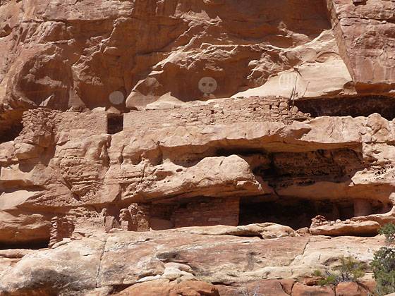
View of jailhous ruins from across the canyon.
This strenuous hike leads to two fascinating ruins, Perfect Kiva and Jailhouse Ruin, in scenic Bullet Canyon. Past the ruins the trail continues down canyon to the confluence with Grand Gulch.
See Trail Detail/Full Description
- Distance: 11.5 miles (round trip) to Jailhouse Ruin
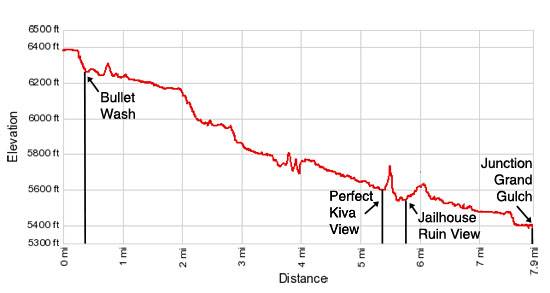
15.8 miles (round trip) to Grand Gulch - Elevation: 6,408-ft. at Trailhead
5,582-ft. at Jailhouse Ruin
5,370-ft. at Grand Gulch - Elevation Gain: -826-ft. to Jailhouse Ruin
-1,038-ft. to Grand Gulch - Difficulty: strenuous
- More Hikes in:
Bears Ears NM / Mexican Hat / Southeast Utah
Why Hike Bullet Canyon
This popular, strenuous hike visits two amazing archaeology sites; Perfect Kiva and Jailhouse Ruin, in beautiful Bullet Canyon. The aptly named Perfect Kiva boasts a well preserved kiva along with some smaller ruins and a good selection of rock art. A new ladder, installed by the BLM, allows hikers to enter the kiva.
Jailhouse ruin, named for the wood lattice window in one of the structures, is built on two levels and features three fascinating circular pictographs. Two structures at the site offer excellent examples of mud-and-wattle construction technique.
The trail down Bullet Canyon to these archaeological gems is not easy. The scenic route, which alternates between walking in the wash and its adjacent benches, includes bypass trails to circumvent pour-offs, boulder jams and other obstacles along the canyon floor. These detours involve slickrock ledges, steep friction pitches and short, steep ascents and descents on rocky terrain.
Past the ruins the trail continues down canyon to the confluence with Grand Gulch. The trail is used as part of multi-day backpacking trips in Grand Gulch, including the most popular loop trip – Kane Gulch to Bullet Canyon.
The trail is best hiked in the spring and fall when temperatures are cooler. Be sure to carry plenty of water and get an early start. The hike will take longer than you think based on the mileage. You should also factor in a good amount of time for enjoying the archaeology sites.
This hike is not recommended for beginners or hikers not experienced with hiking on unmarked canyon trails.
Elevation Profile
Trail Resources
Trail Detail/Full Description / Trail Photo Gallery / Trail Map
Basecamp(s) Information:
Bears Ears NM / Mexican Hat
Region Information:
Southeast Utah
Other Hiking Regions in:
Utah