Lathrop Trail 
Distance: 5.0 - 12.2 miles (round trip)
Island in the Sky District, Canyonlands National Park, near Canyonlands in Southeast Utah
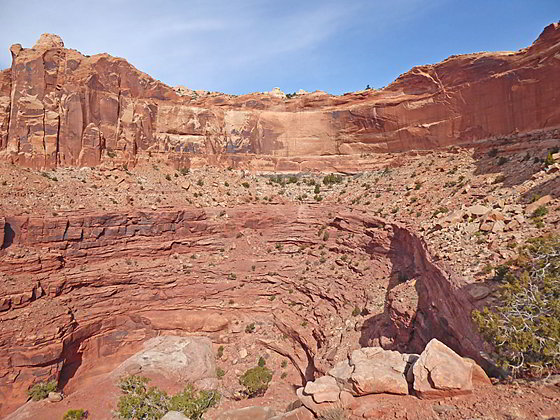
Amphitheater at the head of the side canyon
This trail offers options for all levels of hikers as it travels through diverse landscapes with terrific view of the maze of canyons and red rock formation beneath the Island in Sky mesa. Far reaching vistas stretch east to the La Sal Mountains and south to the Abajo Mountains.
See Trail Detail/Full Description
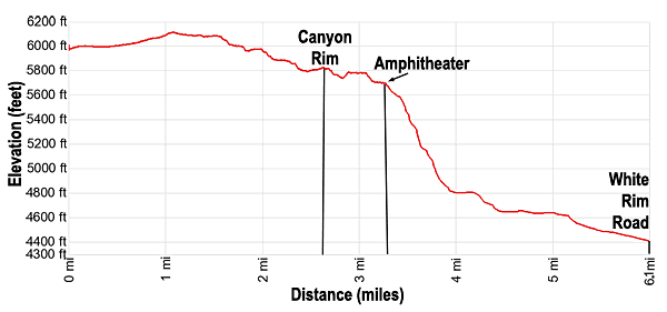
- Distance: 5.0 miles (round trip) to Canyon Rim
6.5 miles (round trip) to the Amphitheater
12.2 miles (round trip) to the White Rim Road - Elevation: 6,120-ft. at Trailhead
5,810-ft. at Canyon Rim
5,710-ft. at the Amphitheater
4,400-ft. at the White Rim Road - Elevation Gain: -650-ft. to Canyon Rim
-1,100-ft. to the Amphitheater
-2,400-ft. to the White Rim Road - Difficulty: strenuous
- More Hikes in:
Canyonlands / Moab / Southeast Utah
Why Hike Lathrop Trail
The Lathrop Trail offers a little something for everyone, with short, medium and long options. The day starts with and easy stroll across grasslands to the rim of the Island in the Sky mesa. Near the rim of the trail starts traveling along sections of slickrock as it descends through an area of scenic sandstone formations. Here views open to the vast expanses of Canyonlands below the rim. The trail then descends to and travels along a bench to a scenic amphitheater. Here the trail drops steeply down Lathrop Canyon on rugged switchbacks, losing over 900-ft. Beyond the switchback a rocky trail leads to the White Rim Road.
This hike is totally exposed to the sun and is only recommended during the Spring and Fall when cooler temperatures make the climb back to the rim tolerable. Be sure to take plenty of water and food. Trekking poles are also helpful during the steep descent and ascent. The rocky switchbacks dropping down from the amphitheater are well constructed but there is a lot of loose rock along the trail. Use care as you descend. This hike is not recommended for anyone with a fear of heights.
Elevation Profile
Trail Resources
Trail Detail/Full Description / Trail Photo Gallery / Trail Map
Basecamp(s) Information:
Canyonlands / Moab
Region Information:
Southeast Utah
Other Hiking Regions in:
Utah