Dead Horse State Park Loop Trail 
Distance: 2.0 - 6.6 miles (loop)
Dead Horse State Park, near Moab in Southeast Utah
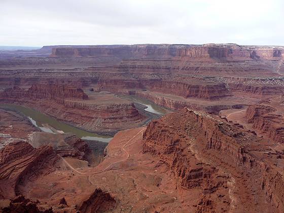
Looking southwest from the trail along the west side of Dead Horse Point.
Amazing vistas of the sculpted canyons, pinnacles and buttes defining the landscape along the Colorado River and nearby Canyonlands National Park are the highlights of this easy 6.0 mile loop hike traveling around the southern end of Dead Horse State Park.
See Trail Detail/Full Description
- Distance: 6.6 miles (loop)
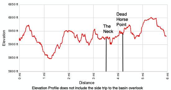
- Elevation: 5,940-ft. at Trailhead
Maximum elevation: 6,010-ft. - Elevation Gain: 70-ft.
- Difficulty: easy-moderate
- More Hikes in:
Moab / Southeast Utah
Why Hike Dead Horse State Park Loop Trail
Dead Horse State Park (5,900-ft.) sits atop a scenic high plateau, towering 2,000-ft. above the Colorado River. The views are as grand as nearby Island in the Sky district of Canyonlands National Park but the trails are not as heavily traveled as those in the park.
Two trails, the West Rim and East Rim, combine to create an easy 6.0 mile loop hike through a high desert landscape with panoramic vistas extending from Canyonlands’ sculpted canyons, pinnacles and buttes to the La Sal Mountains. The hike can be extended by 3.5 miles by including two spur trails to picturesque viewpoints, the Big Horn Overlook and the Colorado Overlook.
Elevation Profile
Trail Resources
Trail Detail/Full Description / Trail Photo Gallery / Trail Map
Basecamp(s) Information:
Moab
Region Information:
Southeast Utah
Other Hiking Regions in:
Utah