Backpack: Texas Pass - Cirque of the Towers - Jackass Pass 
Distance: 24.5 miles (loop)
Bridger and Popo Agie Wildernesses, Bridger-Teton and Shoshone National Forests, near Big Sandy in Wyoming's Wind River Range
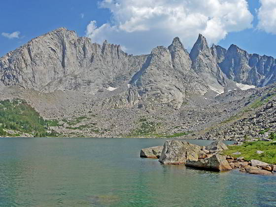
Shadow Lake
For experienced backpackers only, this trip follows a combination of trails and off-trail routes to cross Texas Pass into the stunning Cirque of the Towers. Complete the loop by exiting the Cirque via the Jackass Pass.
- Distance: 24.5 miles
- Elevation: 9,085-ft. at Trailhead
10,287-ft. at Shadow Lake
11,447-ft. at Texas Pass
11,864-ft. at High Point on the Lizard Head Plateau
10,166-ft. Lonesome Lake/Cirque of the Towers
10,790-ft at Jackass Pass
9,085-ft. at Big Sandy Trailhead - Difficulty: strenuous
- More Hikes in:
Big Sandy / Wyoming's Wind River Range
Introduction
From the Big Sandy trailhead follow the Fremont Trail as it heads north, paralleling the west side of the Continental Divide. Along the way the trail passes four beautiful lakes and offers fine views of the massive cirque at the head of the East Fork Valley.
Beyond the head of Marms Lake reach the junction with the Pyramid Lake trail at 7.4 miles. Turn right (northeast) and travel along the Pyramid Lake trail for 1.6 miles and then turn right (north/northeast) on the Shadow Lake trail at 9.0 miles.
The Shadow Lake trail drops to the southern shore of Washakie Creek and then curves to the east, paralleling the creek as it heads up valley on easy grades. Mount Washakie (12,524-ft.) and Big Chief Mountain (12,335-ft.) rim the valley to the north while Easy Day Peak (11,660-ft.) rises to the south. As you ascend lovely views open to the backside of the Cirque of the Towers.
Soon the trail crosses the creek and climbs on moderate grades to Shadow Lake (10,287-ft.) at 11.3 miles. A use trail, which fades in places, now traverses the northern shore and then climbs above the lakeshore to meet the outlet stream for Billys Lake. Follow the stream to Billys southwestern shore. Here a good trail travels by Billys and Barren Lakes to Texas Lake (10,770-ft.), nestled in a stark cirque, at 13.2 miles
At the southern end of Texas Lake locate the route, which break into multiple paths, climbing very steeply through talus and loose graves to the top of Texas Pass (11,447-ft.) at 13.9 miles. Note: The footing to the path is generally OK (trekking poles recommended) unless the trail is covered in snow/ice, then the trail is quite treacherous and requires proper equipment. Don't cross the pass in bad weather or if the weather is taking a turn for the worse.
Atop the pass fine views open to the Cirque of the Towers including Pingora Peak, the Warrior Peaks and Warbonnet Peak. Jackass Pass is seen across the valley to the south. Carefully descend steep scree covered slopes and then meadows to a basin at 14.3 miles. There is a use trail of sorts, which fades and gets lost in the meadows, as you descend.
Beyond the basin a well defined use trail drops steeply down a rocky hillside through meadows and then forest to Lonesome Lake (10,166-ft.), reaching the junction with the North Fork and Jackass Pass trails on the east side of the lake at 15.5 miles. Here the Cirque of the Towers, an amazing spectacle of jagged peaks and spires rising over 12,000-ft., soar above the beautiful lake.
The final leg of the backpack ascends steeply to Jackass Pass (10,790-ft.), accompanied by more great views of the cirque. From the pass the very strenuous path follows a roller coaster route through rocky terrain, climbing over rock slabs and detouring around boulders and rock outcroppings along the west sides of Arrowhead and North Lakes. To the south, views unfold to the high peaks towering above the Deep and Temple Lake drainages.
After three miles, the trail drops down switchbacks to Big Sandy Lake at 18.8. From the lake the Big Sandy Trail descends on easy to moderate grades back to the Big Sandy Trailhead at 24.5. miles.
This great backpack requires a minimum of 2-nights/3-days. I recommend allocating five or more days for the trip. The extra time will enable a more leisurely pace and allow time for day hikes, fishing and exploration.
Backpack Segments
- Segment 1: Big Sandy Trailhead to Marms Lake
- Segment 2: Marms Lake to Shadow Lake Trail Junction
- Segment 3: Shadow Lake over Texas Pass to Cirque of the Towers
- Segment 4: Cirque of the Towers to Big Sandy Trailhead
Elevation Profile
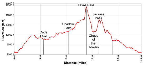
Mileage and Elevation Detail
| Miles | Elevation | Destination | |
|---|---|---|---|
| 0.0 | 9,085-ft. | Big Sandy Trailhead | |
| 0.6 | 9,120-ft. | Junction Sedgewick Meadow / Big Sandy (bear left) | |
| 1.3 | 9,320-ft. | Junction Diamond Lake (bear left) | |
| 1.5 | 9,355-ft. | Junction Fremont Trail (bear right) | |
| 5.5 | 9,741-ft. | Dad’s Lake | |
| 6.8 | 9,878-ft. | Marms Lake | |
| 7.4 | 9,925-ft. | Junction with Pyramid Lake Trail (bear right) | |
| 9.0 | 10,160-ft. | Pass the Shadow Lake trail (continue straight ahead) | |
| 11.3 | 10,287-ft. | Shadow Lake (camping) | |
| 13.2 | 10,770-ft. | Texas Lake | |
| 13.9 | 11,447-ft. | Texas Pass | |
| 15.0 | 10,166-ft. | Lonesome Lake north shore / Cirque of the Towers (camping) | |
| 15.5 | 9,980-ft. | Junction North Fork / Jackass Pass Trails (Lonesome Lake east shore) | |
| 16.3 | 10,790-ft. | Jackass Pass | |
| 18.8 | 9.690-ft. | Big Sandy Lake (camping) | |
| 24.5 | 9,085-ft. | Big Sandy Trailhead |
Trailhead Driving Directions
The Big Sandy Trailhead is located in the southern Wind River Range next to the Big Sandy River.
Directions from Pinedale: From the intersection of Pine Street (US 191) and North Tyler Ave (the Pinedale Tourism office is located on the northeast corner) in Pinedale, WY, drive south on Highway 191 for 11.7 miles and then turn left (east) on WY-353. After 15.5 miles you will notice signs referring to the road as the Big Sandy-Elkhorn Road and after 18 miles the paved road will change to a good packed dirt/gravel surface.
Shortly after the pavement ends go straight through a junction, and drive south crossing the Big Sandy River (Buckskin Crossing). Follow the road for a total of 27.3 miles. Shortly after crossing the Big Sandy River you will reach a junction with the Lander Cutoff Road (the next junction). Turn left on the Lander Cutoff Road. There is a wood sign at the intersection pointing toward the Big Sandy trailhead.
Drive 7.0 miles on the Lander Cutoff Road and then turn left on the Big Sandy Opening Road. Here you will see a sign for the Big Sandy Campground and trailhead. The road now deteriorates and narrows. Blind corners and lush foliage along the road make it hard to see ahead. Drive carefully, following the rocky, rutted road for 9.8 miles to a "Y" intersection. Bear right at the intersection to continue along the Big Sandy Opening Road (Forest Service Road 850). (The road branching to the left leads to the Big Sandy Lodge and Mud Lake.) Follow the road for 0.8 miles to the trailhead parking area, equipped with an outhouse.
Allow an hour and a half to reach the trailhead from Pinedale. The parking area is too small for the number of backpackers visiting the area during the height of the summer. If the parking area is full, find a safe place to park off the access road.
I recommend a high clearance vehicle to reach the trailhead. Passenger cars can make it OK if driven carefully. Check at the Pinedale ranger station before starting your trip to learn about current road and trail conditions. The Ranger Station is located to the east of the Ridleys Grocery Store on US 191 (Pine Street in Pinedale). The entrance to the ranger station is on the Fremont Lake Road. (You can also reach the parking area for the ranger station by driving east through the Ridley’s parking lot.)
This trailhead is remote, so be sure to have a full tank of gas. The dirt road become slippery when wet. The campground at the parking area is tiny, with only 4 sites. I would not plan on camping at the trailhead before starting your backpack.
Trail Resources
Trail Photo Gallery / Trail Map
Basecamp(s) Information:
Big Sandy
Region Information:
Wyoming's Wind River Range
Other Hiking Regions in:
Wyoming