Backpack: Green River Lakes to Island Lake & out Elkhart Park
Segment 4: Indian Pass Trail to Island Lake
Distance: 1.0 miles (one way)
Bridger Wilderness, Bridger-Teton National Forest, near Green River Lakes in Wyoming's Wind River Range
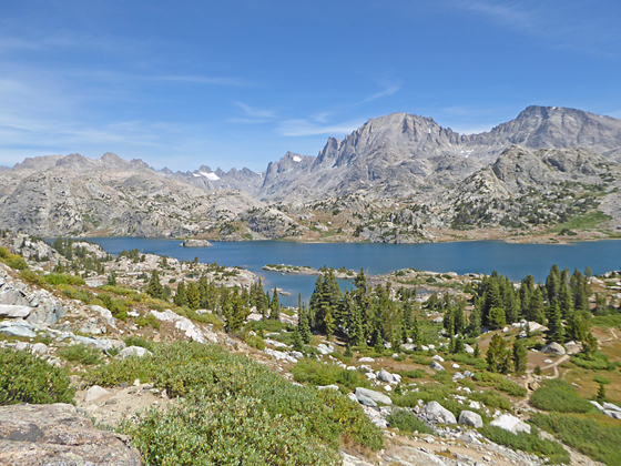
The peaks towering above Titcomb Basin form the backdrop for beautiful Island Lake
- Distance: 1.0 miles
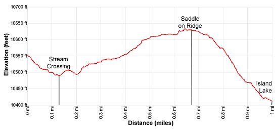
- Elevation: 0.0 miles at Junction Indian Pass/Highline Trails (10,510-ft.)
0.1 miles at Stream crossing (10,490-ft.)
0.7 miles at High point (10,640-ft.)
1.0 miles at Island Lake (10,410-ft.) - Difficulty: moderate
- Basecamp: Green River Lakes
- Region: Wyoming's Wind River Range
Indian Pass Trail to Island Lake Description
This description starts at the junction of the Highline/Continental Divide and Indian Pass trails. (Note the sign at the junction lists the Continental Divide and not the Highline Trail.) Turn northeast at the junction on the Indian Pass Trail to reach Island Lake. The Highline trail, to the southwest, lead to Little Seneca Lake where the trail turns left (southeast) toward Lester Pass. Alternatively, turn right at the head of Little Seneca Lake on the Seneca Lake trail that connects with the Pole Creek trail to the Elkhart Park trailhead.
Follow the Indian Pass Trail as it descends to a small basin and crosses a creek 0.1 miles. Here views encompass Fremont Peak (13,745-ft.), Jackson Peak (13,517-ft.), Mount Helen (13,620-ft.), Mount Sacagawea (13,569-ft.) and Fremont Peak towering above Titcomb Basin. A wall of granite summits, including Bow Mountain (13,020-ft.), Arrowhead Peak (12,792-ft.) and the Titcomb Needles (12,714-ft.), fill the skyline to the northwest.
Beyond the crossing the trail climbs over a low rise and then ascends a draw on easy to moderate grades toward the top of a ridge. The grade eases at 0.5 miles as the trail passes a pretty pond with a backdrop of the peaks to the northwest. Reach the saddle (10,640-ft.) on the ridge at 0.7 miles. Beyond the saddle the trail drops on gentle grades toward Island Lake. Along the way views open to the Fremont Peak, Jackson Peak and Elephant Head towering beyond the eastern end of lake.
The grade steepens as the trail descends toward the lake. At 0.8 miles reach a viewpoint offering a stunning panorama. Here the high peaks towering above Titcomb and Indian Basins form the backdrop for Island Lake. The jagged summits of Twin Peaks (13,185-ft.), Mt. Woodrow Wilson (13,502-ft.), the Sphinx (13,258-ft.), Bob’s Tower (13,040-ft.) and Miriam Peak (13,080-ft.) rise above the head of Titcomb Basin. Mount Helen, Mount Sacagawea and Fremont Peak rim the basin’s eastern wall while American Legion Peak (13,205-ft.), the Titcomb Needles and Peak 12450, to name a few, form the western wall. Jackson Peak (13,517-ft.) and Ellingwood Peak (13,052-ft.), along with a number of unnamed summits, tower above Indian Basin to the northeast. Closer at hand, Island Lake lies nestled amid granite knolls with Elephant Head Peak rising to the east.
From the viewpoint descend steeply down a rocky slope and then through meadows with scattered trees to an unmarked junction above Island Lake’s (10,346-ft.) eastern shore at 1.0 mile. Along the way pass a few spur trails leading to campsites.
At the unmarked junction the trail branching to the left (northwest) leads to scenic campsites along the lake’s southwestern shore. The Indian Pass trail continues straight ahead (northeast) toward Indian and Titcomb Basins.
Island Lake is an extremely popular destination, so don’t expect solitude. On the knoll at the south end of the lake are tightly packed, overused campsites. Please try to avoid camping here. The further you get from the junction at the south end of the lake, the more likely you will find a campsite with some privacy. Additional campsites are located along Island Lake’s northeastern shore and in the basin above the waterfall on the northeast side of the lake. Please respect the areas closed for regeneration along Island Lake’s heavily used eastern shore.
Campsites are also located in Titcomb and Indian Basins. Both basins are above timberline so the sites are exposed with large rocks offering the only protection. Finding legal campsites that are at least 200-ft. from trails and water is somewhat challenging in both basins. Hanging food is also problematic due to the lack of trees. You will need to find a large boulder to hang your food or carry a bear container.
Return to Segment 3: Highline: Elbow Lake to Indian Basin Trail
Go To Segment 5: Island Lake to Elkhart Park
Elevation Profile
Backpack Segments
- Introduction: Green River Lakes to Island Lake & out Elkhart Park
- Segment 1: Highline: Green River Lakes to Trail Creek Park
- Segment 2: Highline: Trail Creek Park to Elbow Lake
- --- Side Trip: Peak Lake
- Segment 3: Highline: Elbow Lake to Indian Basin Trail
- --- Side Trip: Island Lake Backdoor
- Segment 4: Indian Pass Trail to Island Lake
- --- Side Trip: Titcomb Basin
- --- Side Trip: Indian Basin and Pass
- --- Side Trip: Island Lake Waterfall Hike
- Segment 5: Island Lake to Elkhart Park
Driving Directions to Elkhart Park Trailhead
Green River Lakes Trailhead: Located just off the northwest shore of scenic Green River Lake, the trailhead offers access to several trails including the Highline Trail, which is part of the Continental Divide National Scenic Trail, Clear Creek Trail, and the Roaring Fork Trail.
Directions from Pinedale: From the intersection of Pine Street (US 191) and North Tyler Ave (the Pinedale Tourism office is located on the northeast corner) in Pinedale, WY, drive west on Highway 191 (West Pine Street) for 6 miles and then turn right on WY-352 toward Cora. Follow WY-352 for 25.3 miles to the National Forest boundary, where the pavement ends. Continue straight ahead on Green River Lakes Road (Forest Service Road 600). (Stay along the east side of the river, ignoring any roads branching to the left.)
Follow Green River Lakes Road for 18.5 miles to a signed intersection for the Green River Lakes campground and trailhead. The road to the right leads to the campground. We bear slightly left, staying on the Green River Lakes Road. Continue on the road for 0.2 miles and then turn left at the signed intersection for the trailhead parking area. Drive along the spur road for 0.1 miles to a “Y” intersection and turn right into the trailhead parking area. The road to the left leads to the equestrian parking lot. The trailhead is located at the southwest end of the parking area.
The 50 mile trip should take about 1 hour and 45 minutes. Passenger cars can typically make it to the trailhead. Check at the forest service office in Pinedale for current road conditions.
Elkhart Park Trailhead: From the intersection of Pine Street (US 191) and North Tyler Ave (the Pinedale Tourism office is located on the northeast corner) in Pinedale, WY, drive east on Highway 191 (East Pine Street) for 0.3 miles and bear left onto Fremont Lake Road. Follow this road for 14.3 miles and turn right into the large parking area for the Elkhart Park/Pole Creek Trailhead. After the first 3.0 miles the road will turn into Skyline Drive/Forest Service Road 370740. The trailhead is located at the northeast end of the parking lot between the outhouse and the trailhead kiosk. It should take about 25 minutes to drive the trailhead. The last section of the road has some holes and uneven spots.
Trail Resources
- Backpack Intro
- Segment Photo Gallery
- Segment Map
- Trailhead(s) Information: Green River Lakes
- Region Information: Wyoming's Wind River Range
- Other Hiking Regions in: Wyoming