Backpack: New Fork-Doubletop-Palmer Lake Loop 
Distance: 47.8 miles (loop)
Bridger Wilderness, Bridger-Teton National Forest, near New Fork Lakes in Wyoming's Wind River Range
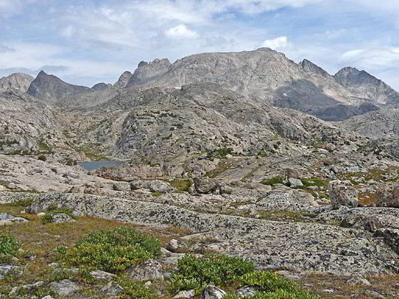
Elbow Lake Basin
This great loop backpack out of New Fork Lakes travels through a variety of terrains ranging from impressive canyons with sheer granite walls to beautiful alpine lake basins surrounding by towering peaks.
- Distance: 47.8 miles
- Elevation: 7,895-ft. at New Fork Lakes Trailhead
7.825-ft. at Upper New Fork Lake
7,850-ft. at Junction Lowline/Doubletop Mtn. Trail
8,530-ft. at 1st New Fork River Crossing
8,640-ft. at 2nd River Crossing
8,880-ft. at Palmer Lake Junction
10,680-ft. at 1st Lozier Lakes Pass
10,940-ft. at 2nd Lozier Lakes Pass
10,270-ft. at Clark Lake
9,300-ft. at Junction Highline Trail at Trail Creek Park 9,640-ft. at Junction Vista Pass Trail
10,390-ft. at Green River Pass
10,330-ft. at Junction Doubletop Mtn Trail at Summit Lake
10,880-ft. at Elbow Lake Basin Overlook
10,950-ft. at Junction Shannon Pass Trail
10,330-ft. at Junction Doubletop Mtn Trail at Summit Lake
10,780-ft. at High Point on Ridge
10,180-ft. at Junction Palmer Lake Trail
8,880-ft. at Junction New Fork Trail
7,895-ft. at New Fork Lakes Trailhead - Difficulty: strenuous
- More Hikes in:
New Fork Lakes / Wyoming's Wind River Range
Introduction
The interesting loop hike ascends a dramatic canyon, visits lovely lake basins and then climbs to an alpine wonderland of sparkling lakes set amid ice-polished granite knobs surrounded by soaring peaks. The return leg of the backpack wanders through seldom visited lake basins and then descends a rugged canyon where it reconnects with the New Fork Trail back to the trailhead.
The first segment of the backpack follows the New Fork Trail, which features dramatic views of the granite walls towering above New Fork Canyon and a delightful traverse of the beautiful meadows of New Fork Park. The park is a great place to spend your first night.
Beyond New Fork Park the path climbs to the lovely Lozier Lakes Basin and crosses two passes with stunning, panoramic views of the northern Wind’s high peaks, including Gannett Peak (13,809-ft.) - Wyoming’s highest summit. After cresting the second pass the trail drops down to Clark Lake and then to the Highline trail at Trail Creek Park, where nice campsites are set amid meadows and clusters of trees. Additional camping is found along Trail Creek.
From Trail Creek Park we follow the south-bound Highline Trail as it ascends to Summit Lake, crosses the Pine Creek drainage and then follows an undulating trail through lakes and tarns set amid meadows and timber clad knobs. Along the way the trail turns to the east and then northeast as it climbs to the magnificent Elbow Lake basin.
The trail through the basin stays well above timberline as it traverses small meadows growing amid ice-polish rock outcroppings and erratic boulders. Massive Elbow Lake, along with a collection of smaller lakes and tarns, lie nestled in rocky bowls. Surrounding the basin is an amazing collection of 12,000-13,000-ft peaks.
Select a campsite for the third night based on the weather and your tolerance for camping in exposed terrain. Protected campsites are located around the Twin Lakes, located 5.4 miles past Trail Creek Park. Scenic, albeit exposed camping spots are situated around the Elbow Lake basin.
I strongly recommended a few layover days at the third campsite to allow time to explore the Elbow Lake Basin and take day hikes to Peak Lake and/or the Jean Lakes. Beautiful Peak Lake, nestled in a rugged bowl at the foot of a magnificent cirque of jagged peaks, is reach by walking to a junction at the head of the Elbow Lake basin and then following the Shannon Pass trail northwest for 1.8 miles.
To reach the Jean Lakes, turn southeast at the junction and continue along the Highline as it crosses a divide and then drops into the headwaters of Fremont Creek. The trail now descends along Fremont Creek, passing through the stunning Jean Lakes basins, set amid an incredible array of soaring peaks. It is a 4.4 miles round-trip hike from the junction to the head of Lower Jean Lake.
The return leg of the loop heads back to Summit Lake and turns west on the Doubletop Mountain trail, signed for Palmer Lake, which traverses the beautiful No Name and Cutthroat Lakes basin. A high ridge separating the two basins features panoramic views of the high peaks ranging from Gannett Peak to the summits towering above Titcomb and Indian Basin’s to the southeast.
Beyond the Cutthroat Lakes the trail travels through small basins scattered with tarns, rocky knolls and clusters of trees to Palmer Lake. Here we leave the Doubletop Mountain trail and follow the Palmer Lake trail north, crossing a divide separating the Lake Creek and Palmer Canyon drainages and then descending the South Fork of Palmer Canyon and the Palmer Canyon to a junction with the New Fork Trail at New Fork Park. The final leg of the backpack retraces our steps to the New Fork trailhead.
Backpack Segments
- Segment 1: New Fork Lakes to New Fork Park/Palmer Lake Trail Junction
- Segment 2: New Fork Park to Trail Creek Park via Lozier Lakes
- Segment 3: Highline Trail: Trail Creek Park to Elbow Lake Basin
- --- Side Trip: Peak Lake
- --- Side Trip: Jean Lakes Segment of the Highline Trail from Elbow Lake Basin to Island Lake
- Segment 4: Highline Trail: Elbow Lake Basin to Summit Lake
- Segment 5: Doubletop Mountain and Palmer Lake Trails
- Segment 6: New Fork Park to Trailhead
Elevation Profile
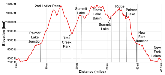
Mileage and Elevation Detail
| Miles | Elevation | Destination | |
|---|---|---|---|
| 0.0 | 7,895ft. | New Fork Lakes Trailhead | |
| 1.5 | 7.825ft. | Upper New Fork Lake | |
| 2.1 | 7,850ft. | Junction Lowline/Doubletop Mtn. Trail | |
| 5.8 | 8,530ft. | 1st New Fork River Crossing | |
| 6.5 | 8,640ft. | 2nd River Crossing | |
| 8.5 | 8,880ft. | Palmer Lake Junction | |
| 12.2 | 10,680ft. | 1st Lozier Lakes Pass | |
| 14.6 | 10,940ft. | 2nd Lozier Lakes Pass | |
| 23.1 | 10,270ft. | Clark Lake | |
| 18.2 | 9,300-ft. | Junction Highline Trail at Trail Creek Park | |
| 18.9 | 9,640-ft. | Junction Vista Pass Trail | |
| 19.7 | 10,390ft. | Green River Pass | |
| 21.5 | 10,330ft. | Junction Doubletop Mtn Trail at Summit Lake | |
| 24.5 | 10,880ft. | Elbow Lake Basin Overlook | |
| 26.4 | 10,950ft. | Junction Shannon Pass Trail | |
| 31.3 | 10,330ft. | Junction Doubletop Mtn Trail at Summit Lake | |
| 33.8 | 10,780ft. | High Point on Ridge | |
| 35.9 | 10,180ft. | Junction Palmer Lake Trail | |
| 37.2 | 10,780ft. | Saddle above Palmer Lake | |
| 39.3 | 8,880ft. | Junction New Fork Trail | |
| 45.7 | 7,850ft. | Junction Lowline/Doubletop Mtn. Trail | |
| 47.8 | 7,895ft. | New Fork Lakes Trailhead |
Trailhead Driving Directions
New Fork Lakes Trailhead: Located on the northeast shore of Lower New Fork Lake, this trailhead offers an alternative and less crowded access point to the northwestern Wind River range without the long drive to Green River Lakes.
Directions from Pinedale: - From the intersection of Pine Street (US 191) and North Tyler Ave (the Pinedale Tourism office is located on the northeast corner) in Pinedale, WY, drive west on Highway 191 (West Pine Street) for 6 miles and then turn right on WY-352 toward Cora. Follow WY-352 for 14.3 miles and turn right on County Road 162, a dirt road signed for New Fork Lakes. Follow the road for 4.8 miles to the end of the road. Along the way the road name will change to New Fork Lakes Road/Forest Service Road 732/730. The New Forks Lake parking area is on the left. The trailhead is located at the northeast corner of the lot.
The 25.2 mile trip should take about 40 minutes. Passenger cars can typically make it to the trailhead without any problems.
Trail Resources
Trail Photo Gallery / Trail Map
Basecamp(s) Information:
New Fork Lakes
Region Information:
Wyoming's Wind River Range
Other Hiking Regions in:
Wyoming